St Ann’s Hospital, London
The 50 acre former St Ann’s Hospital site in Harringay, London has a rich history dating back to the late 19th century. The hospital, which was built in 1892, served the local community for over a century, providing medical care and treatment to thousands of patients over the years. However, as healthcare needs and technologies evolved, the hospital was eventually closed down in the late 20th century. Since then, the site has remained largely unused and abandoned, with the exception of a few temporary uses.
However, in 2021, Catalyst Housing Limited and Hill Group UK, decided to develop the site into a mixed-use development that would provide new housing, community facilities, and much-needed infrastructure for the local community. To support their hybrid planning application for this development, the two companies commissioned Digital Inc to carry out a full 3D measured survey of the site. Using the latest technology and techniques, the team at Digital Inc provided 3D laser scanning and underground survey services to produce high detail 3D Revit models, and 360 HDR photography of the entire site, including neighbouring Rights Of Light considerations.
Using terrestrial laser scanning, the team accurately captured the site and buildings where safely accessible, without disturbing the residents of the neighbouring properties. For areas that were not safely accessible, Digital Inc deployed a drone to fly along the property boundary, capturing all essential aspects and conditions. Drones are faster and more efficient than traditional survey methods, which can reduce project timelines and costs. Additionally, using a drone eliminated the need for scaffolding, ladders or other equipment, which also significantly saved on costs. The benefits of combining 3D laser scanning and drone were evident in the substantial time savings and kept the project within budget.
“Thank you for your hard work, it’s been a really positive experience working with you”
Hannah Utting, Catalyst Housing Ltd
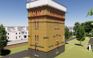
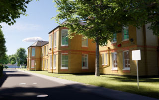
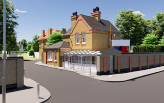
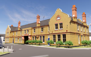
Seven of the buildings on the site were heritage listed, and it required these to be modelled to a high level of detail (LOD400) with 360 photographic records in high definition. It was essential to understand where the existing underground services were situated for the coordination of proposed infrastructure, and 3D tracing, CCTV and inspection services of all manhole and drainage covers were accurately measured and modelled.
One of the major advantages of the detailed survey performed by Digital Inc, utilizing point cloud data, LOD400 Revit models and HDR photography, was the ability to inspect the current state of the site with a high level of precision without having to set foot on site. This enabled the architects to make informed choices regarding the design and development of the project, maintain the historical authenticity of the heritage-listed buildings, and avoid disrupting the neighbouring properties.
Overall, Digital Inc empowered the client and stakeholders with stunningly comprehensive results in high detail and accuracy, all within a timely manner.
For further details of the masterplan, please visit this link: https://consultation.chg.org.uk/st-anns-about-the-project.
Another successful project delivered as promised.

St Ann’s Hospital, London
The 50 acre former St Ann’s Hospital site in Harringay, London has a rich history dating back to the late 19th century. The hospital, which was built in 1892, served the local community for over a century, providing medical care and treatment to thousands of patients over the years. However, as healthcare needs and technologies evolved, the hospital was eventually closed down in the late 20th century. Since then, the site has remained largely unused and abandoned, with the exception of a few temporary uses.
However, in 2021, Catalyst Housing Limited and Hill Group UK, decided to develop the site into a mixed-use development that would provide new housing, community facilities, and much-needed infrastructure for the local community. To support their hybrid planning application for this development, the two companies commissioned Digital Inc to carry out a full 3D measured survey of the site. Using the latest technology and techniques, the team at Digital Inc provided 3D laser scanning and underground survey services to produce high detail 3D Revit models, and 360 HDR photography of the entire site, including neighbouring Rights Of Light considerations.
Using terrestrial laser scanning, the team accurately captured the site and buildings where safely accessible, without disturbing the residents of the neighbouring properties. For areas that were not safely accessible, Digital Inc deployed a drone to fly along the property boundary, capturing all essential aspects and conditions. Drones are faster and more efficient than traditional survey methods, which can reduce project timelines and costs. Additionally, using a drone eliminated the need for scaffolding, ladders or other equipment, which also significantly saved on costs. The benefits of combining 3D laser scanning and drone were evident in the substantial time savings and kept the project within budget.
“Thank you for your hard work, it’s been a really positive experience working with you”
Hannah Utting, Catalyst Housing Ltd
Seven of the buildings on the site were heritage listed, and it required these to be modelled to a high level of detail (LOD400) with 360 photographic records in high definition. It was essential to understand where the existing underground services were situated for the coordination of proposed infrastructure, and 3D tracing, CCTV and inspection services of all manhole and drainage covers were accurately measured and modelled.
One of the major advantages of the detailed survey performed by Digital Inc, utilizing point cloud data, LOD400 Revit models and HDR photography, was the ability to inspect the current state of the site with a high level of precision without having to set foot on site. This enabled the architects to make informed choices regarding the design and development of the project, maintain the historical authenticity of the heritage-listed buildings, and avoid disrupting the neighbouring properties.
Overall, Digital Inc empowered the client and stakeholders with stunningly comprehensive results in high detail, accuracy all within a timely manner.
For further details of the masterplan, please visit this link: https://consultation.chg.org.uk/st-anns-about-the-project.
Another successful project delivered as promised.


